
On-Trip navigation adjustments
During roadworks, we strive to keep travelers well-informed about the optimal route and anticipated delays. While physical signage remains important, digital solutions are becoming increasingly prevalent. As road users increasingly rely on navigation systems, physical signs are becoming less effective.
Our tools enable us to provide clients with a digital solution that complements existing physical measures, ensuring a seamless and informative experience for travelers. By implementing real-time map adjustments, we:
- Enhance road safety by reducing the need for drivers to search for detours.
- Mitigate traffic congestion around work zones by proactively guiding drivers to alternative routes.
- Provide up-to-date information to ensure a smooth journey.
TRAFFIC REPORTAL
Our Traffic Reportal is a real-time tool that integrates data from various service providers. It allows us to proactively update navigation systems with the latest information on road closures and other disruptions. By using this tool, we can effectively support our clients and ensure that travelers always have the most accurate and up-to-date information.
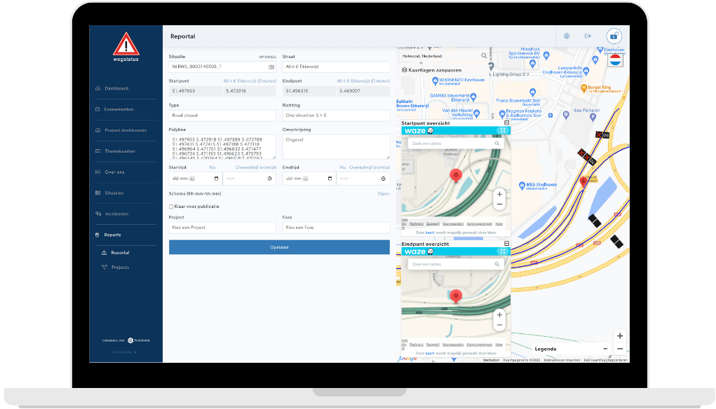
The only exception to this is Google Maps, which receives information indirectly through Waze. While we have a direct connection with Google, real-time data sharing is not yet available. Our real-time data includes road closures, lane restrictions, stationary work vehicles, pilot cars, and other relevant traffic information.
ROAD CLOSURES AND ADJUSTMENTS
Road safety is paramount, especially during roadworks. The dynamic nature of roadworks often leads to reduced driver attention and increased risks for both road workers and motorists. To mitigate these risks, we provide real-time traffic updates to help prevent accidents. Whether it’s large-scale roadworks, unexpected incidents, or seasonal traffic surges, TripService ensures that navigation systems are updated with the latest traffic information. Our data is integrated into popular navigation apps like Waze, TomTom, Apple Maps, and Google Maps, as well as logistics systems and in-car navigation systems of major automotive brands. While our partners ultimately decide which information to display, we maintain direct communication channels to address any issues promptly.

DETOUR ROUTES
Using the data we provide, navigation service providers can efficiently distribute traffic and suggest optimal detours. These routes are carefully planned to comply with road classifications and legal restrictions, such as those related to destination traffic.
DESTINATION TRAFFIC
To effectively manage traffic, it’s essential to have a legal framework in place. By temporarily designating roads or areas as “destination traffic,” we can alert drivers approaching these zones and restrict access to those without a legitimate reason to be there. This helps to reduce congestion and improve safety.
Een van onze klanten Traffic Service Nederland laat zien hoe zij de Traffic Reportal inzetten.
Discover more

Pre-Trip: Information Campaigns
TripService informs travelers pre-trip via Waze, social media and Google, targeting location, audience and traffic needs for maximum impact.

Post-Trip: Traveler analysis
After campaigns, TripService provides in-depth analysis of reach, sentiment and execution to measure impact and improve future projects.